Create OpenAir file

I would like to create OpenAir files that display the polygons of the LFAs from NFL-2025-1-3686.

My first attempts failed.
Here is my test:

AC GP
AN LFA1
AL SFC
AH SFC
DP 53:11.50N 007:13.00E
DP 53:09.50N 007:34.00E
DP 53:10.67N 007:40.50E
DP 53:07.00N 007:57.00E
DP 53:04.08N 008:10.55E
DP 53:03.58N 008:11.83E
DP 53:03.43N 008:13.50E
DP 52:57.50N 008:41.33E
DP 52:51.70N 008:42.50E
DP 52:50.92N 008:43.33E
DP 52:50.00N 008:42.75E
DP 52:48.50N 008:39.91E
DP 52:48.00N 008:38.50E
DP 52:47.00N 008:38.00E
DP 52:43.25N 008:32.25E
DP 52:42.83N 008:30.75E
DP 52:42.00N 008:28.67E
DP 52:43.25N 008:18.67E
DP 52:43.75N 008:17.50E
DP 52:43.00N 008:16.50E
DP 52:41.00N 008:14.45E
DP 52:40.00N 008:14.25E
DP 52:39.08N 008:13.50E
DP 52:26.33N 007:58.00E
DP 52:31.33N 007:40.25E
DP 52:39.33N 007:29.70E
DP 52:40.25N 007:29.17E
DP 52:41.00N 007:28.00E
DP 52:42.00N 007:24.00E
DP 52:53.00N 007:32.50E
DP 52:57.00N 007:36.00E
DP 52:58.00N 007:26.00E
DP 52:56.00N 007:24.50E
DP 52:42.00N 007:15.00E
DP 52:41.00N 007:15.17E
DP 52:43.08N 007:03.83E
DP 53:11.50N 007:13.00E

Hello Jürgen,

Welcome :slight_smile: …basically, I think your idea is great.

Question: Who will keep the whole thing up to date? Who/where is the source of the master data?

I know, that doesn’t answer your question.

If necessary, we might need to create a separate section for such quite interesting things?

→ which would then also be useful for VFRnav. @Hermann

After all, the project thrives on exactly such good ideas.

Pilot greetings,

Karsten

I’ve tinkered with circuit patterns, maybe you can extract something from it?

  • Status: 2023-06-15 kba
  • additional UL circuits for VFRnav V3

  • EDXTHI UL-Mellenthin
    AC F
    AN UL-PR 12/30 600x30 grass…do not use the concrete runway!
    AH 500 ft
    DP 53:55:08.471 N 14:01:45.270 E
    V D=+
    V X=53:55:23.646 N 14:01:35.055 E
    DB 53:55:16.136 N 14:01:26.304 E,53:55:24.330 N 14:01:19.642 E
    V D=+
    V X=53:55:42.834 N 14:01:37.977 E
    DB 53:55:43.539 N 14:01:22.094 E,53:55:50.588 N 14:01:46.959 E
    V D=+
    V X=53:55:04.351 N 14:03:11.913 E
    DB 53:55:12.562 N 14:03:21.427 E,53:54:54.941 N 14:03:17.369 E
    V D=+
    V X=53:54:58.610 N 14:02:40.853 E
    DB 53:54:48.738 N 14:02:46.576 E,53:54:50.011 N 14:02:30.833 E
    DP 53:55:00.838 N 14:02:04.115 E
    DP 53:55:00.838 N 14:02:04.115 E
    V D=-
    V X=53:54:58.610 N 14:02:40.853 E
    DB 53:54:50.011 N 14:02:30.833 E,53:54:48.738 N 14:02:46.576 E
    V D=-
    V X=53:55:04.351 N 14:03:11.913 E
    DB 53:54:54.941 N 14:03:17.369 E,53:55:12.562 N 14:03:21.427 E
    V D=-
    V X=53:55:42.834 N 14:01:37.977 E
    DB 53:55:50.588 N 14:01:46.959 E,53:55:43.539 N 14:01:22.094 E
    V D=-
    V X=53:55:23.646 N 14:01:35.055 E
    DB 53:55:24.330 N 14:01:19.642 E,53:55:16.136 N 14:01:26.304 E
    DP 53:55:08.471 N 14:01:45.270 E

Thank you.
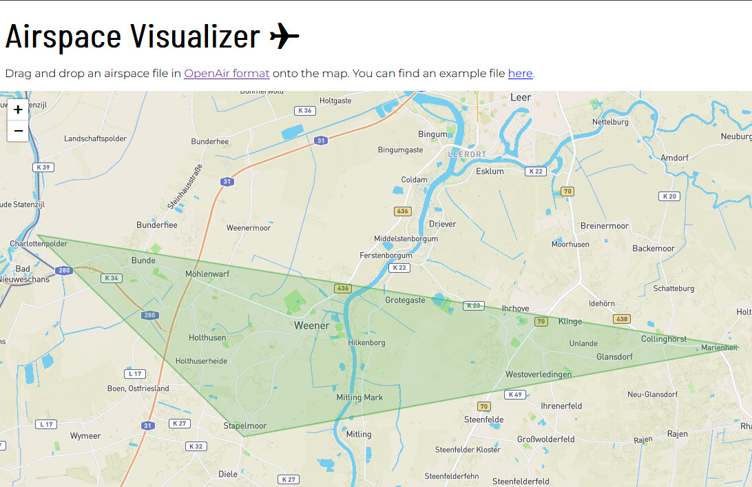
Yes, I’m familiar with the airspace file. It’s too coarse for me.
I’d like it to be a bit more detailed.
I’ve already created a KML file for Google Earth.
That’s very nice.

I wanted to see if I could also display the area in VfrNav.
I created a small file for experimenting and was able to add it in VfrNav under External Map Contents. However, it doesn’t display. The description says that external map contents are displayed on the internal map, yet I don’t see anything.

My experimental file currently looks like this:

AC Q
AN LFA1
AL GND
AH 1500ft
DP 53:11:29.71 N 007:12:59.44 E
DP 53:09:29.38 N 007:33:59.54 E
DP 53:07:52.48 N 007:19:10.90 E

Of course, it no longer has anything to do with the LFAs.

In the Airspace Visualizer the above polygon is also displayed.

grafik

Cool Jürgen🙂…I know a colleague well who builds the course lap files. Perhaps we could have an exchange of experience? (I’m out of my depth on this subject) Interested? Then I could ask him. As for it not being displayed: it could be a permissions issue on the import storage location. Try putting them in your personal documents.

Kind regards, Karsten

→ …no, it still doesn’t work. just tried that too.

Thank you for your support

:grinning_face:

Good evening,

I regularly create OpenAir files for VFRnav. It is important that the coordinate format is correct. VFRnav expects DD:MM:SS.SS here; at the top of the file you have DD:MM.SS.

Regarding airspace class “GP”, I’m not sure how or whether it should be represented. Try something standard here.

AC A
AN LFA1
AL SFC
AH SFC
DP 53:11:30.00N 007:13:00.00E
DP 53:09:30.00N 007:34:00.00E
DP 53:10:40.20N 007:40:30.00E
DP 53:07:00.00N 007:57:00.00E
DP 53:04:04.80N 008:10:33.00E
DP 53:03:34.80N 008:11:49.80E
DP 53:03:25.80N 008:13:30.00E
DP 52:57:30.00N 008:41:19.80E
DP 52:51:42.00N 008:42:30.00E
DP 52:50:55.20N 008:43:19.80E
DP 52:50:00.00N 008:42:45.00E
DP 52:48:30.00N 008:39:54.60E
DP 52:48:00.00N 008:38:30.00E
DP 52:47:00.00N 008:38:00.00E
DP 52:43:15.00N 008:32:15.00E
DP 52:42:49.80N 008:30:45.00E
DP 52:42:00.00N 008:28:40.20E
DP 52:43:15.00N 008:18:40.20E
DP 52:43:45.00N 008:17:30.00E
DP 52:43:00.00N 008:16:30.00E
DP 52:41:00.00N 008:14:27.00E
DP 52:40:00.00N 008:14:15.00E
DP 52:39:04.80N 008:13:30.00E
DP 52:26:19.80N 007:58:00.00E
DP 52:31:19.80N 007:40:15.00E
DP 52:39:19.80N 007:29:42.00E
DP 52:40:15.00N 007:29:10.20E
DP 52:41:00.00N 007:28:00.00E
DP 52:42:00.00N 007:24:00.00E
DP 52:53:00.00N 007:32:30.00E
DP 52:57:00.00N 007:36:00.00E
DP 52:58:00.00N 007:26:00.00E
DP 52:56:00.00N 007:24:30.00E
DP 52:42:00.00N 007:15:00.00E
DP 52:41:00.00N 007:15:10.20E
DP 52:43:04.80N 007:03:49.80E
DP 53:11:30.00N 007:13:00.00E

Many thanks.
Unfortunately, that didn’t help either.
In the Airspace Visualizer, the above file is displayed correctly.