While preparing for a trip I ran into a few issues with the chart for the Netherlands. Some information seems to be missing.
The DutchMil frequency is not shown (well, that’s not so important).
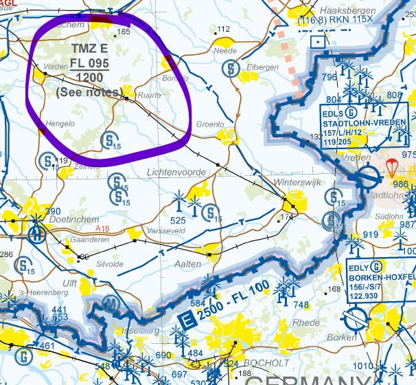
At least the following TMZ (Transponder Mandatory Zone) is missing. Actually, in the Netherlands there is almost everywhere a TMZ above 1,200 ft MSL. These are not particularly problematic; you just need an active Mode S transponder. But you do need to know this:
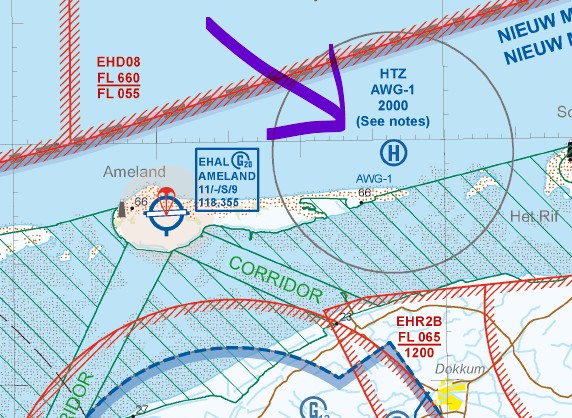
The North Sea‑typical HPZs / HTZs (Helicopter Traffic Zones) are missing; these are established to service the oil platforms and have requirements that are almost like control zones. Example:
The screenshots come from the official and current VFR chart. It is (commendably!) available for free as a download: https://www.lvnl.nl/diensten/aip/downloads
However, the corresponding information is also available on OpenFlightmaps.
thanks! Searching the Dutch AIP for details of the regulations regarding the helicopter traffic zones (HTZ) and helicopter protection zones (HPZ) is really no fun. It does, however, basically seem to confirm what people say.
In AIP Enroute 2.2 the HTZs and HPZs, together with RMZs, TMZs and ATZs, are classified as “OTHER REGULATED AIRSPACE”, here again under “6 NORTH SEA OPERATIONS, FLIGHT INFORMATION SERVICE AND ALERTING SERVICE”. The following applies to these overall:
“6.1 General
Amsterdam FIC provides FIS and ALRS in the North Sea area Amsterdam and the North Sea area V (see paragraph 6.1.2) to safeguard military and civil air traffic above the North Sea up to and including FL 055. For area boundaries see ENR 6 chart En-route - ICAO.”
→ so you basically have to call Amsterdam FIC; Dutch Mil, for example, won’t help.
Details of the respective extents can then be found in “6.2.2 Helicopter traffic zones (HTZ) and helicopter protection zones (HPZ)”.
Regardless of any possible obligations to report before entry, it would in any case be desirable to have the respective zones displayed, if only to avoid accidentally barreling into high-frequency helicopter traffic. An overflight is possible, provided the extent is known.
6.3.3.1 Crossing or overflying of HTZs/HPZs
A pilot operating over the North Sea, shall make sure that crossing or overflying at his level is safe, especially in IMC.

Information on possible flight operations within HTZs/HPZs will be provided by the Amsterdam flight information centre.
In Germany this would probably be a danger area (ED-D).
Nevertheless I’ll include these for now. The unfortunate thing is that for us VFR pilots probably only the HTZ at Ameland near the coast is relevant.
Maybe an NL-native pilot can add something about it when they have the chance
In aviation, and more specifically in the context of maritime (offshore) operations such as in the North Sea, the abbreviations HPZ and HTZ refer to specific airspaces established to manage the heavy helicopter traffic serving oil and gas platforms or wind farms.
Here is their exact meaning:
1. HPZ: Helicopter Protected Zone(Protected zone for helicopters)
An HPZ is an airspace of defined dimensions established above and around offshore installations.
Objective: Protect the approach, departure and transit trajectories of helicopters operating between the coast and the platforms.
Rules: Although it is often class G airspace (uncontrolled), entry into an HPZ is subject to strict rules via the Aeronautical Information Publication (AIP). Filing a flight plan and maintaining continuous radio contact are generally required to ensure that helicopters do not conflict with other low-altitude aircraft (such as light aircraft or military fighters).
An HTZ is a traffic zone that specifically surrounds an offshore aerodrome (generally a platform or group of platforms equipped with helidecks).
Objective: It is similar to terrestrial ATZs (Aerodrome Traffic Zones). It serves to protect traffic operating in the immediate vicinity of the structure, notably during the critical phases of takeoff, landing, or circuit/holding.
Operation: It requires pilots to maintain a strict radio listening watch on an assigned frequency to self-regulate or follow information provided by the platform’s radio operator (Radio Operator).
In summary: These two types of zones often operate alongside HMR (Helicopter Main Routes — the main helicopter routes). They allow segregation or coordination of traffic in very congested maritime areas where conventional low-altitude radar coverage may be limited.